India to America distance, location, road map and direction
India is located at the longitude of 77.2 and latitude of 28.58. America is located at the longitude of -77.04 and latitude of 38.9.India to America distance
Distance between India and America is 12053 KM/ 7489.5 miles. Here the starting location is Indian capital New delhi and the destination location is American city Washingdon Dc. You can also use our distance calculator to get distance from other cities of India to American cities.India to America distance by road
Here we are assuming the starting location is Indian capital New delhi and the destination location is American city Washingdon Dc.India to America distance by road via europe
India New delhi to Usa Newyork by road and sea route distance is 17408 kilometer via Port of Algeciras,span.India to America flight distance
India to America flight distance is 12053 KM .Delhi to New York flight distance is around 12053 KM, and a direct flight usually takes around 17 hours up to 24 hours or more, depending on the number and duration of the layovers. The flights between Delhi to New York normally stops at Amsterdam, London, Paris, Rome, Dubai, Moscow, Frankfurt, etc.
India to America via Bering Strait
How to reach America from India by land route
How did first human beings came to North America and cross Bering Strait, on foot or by boat Across the Atlantic via the polar ice cap 20,000 ago.
There are different route available to reach America from India theoretically. At present there is no direct land route. You can go towards east via Russia. Another one is you can go towards west of India via europe. In both way you have to cross sea. In europe route the sea distance is more. Russia to USA via Bering Strait is less. So at present it is not possible go by road.
- step 01.Exit India via Moreh, Imphal, Manipur.
- step 02. Enter Myanmar. Driving through, you will exit from Myanmar via Myawaddy border.
- step03. Enter Thailand and exit via Chiang Mai.
- step 04.Enter China via the Mohan port.
- step 05.Go east and exit China via Hunchun port.
- step 06. Immediately enter Russia to go towards Cape Dezhnev(Bering Strait).
- step 07. No proper route at present(writing time) to cross Bering Strait
- step 08. If it is possible to cross Bering Strait from Cape Dezhnev to Cape Prince of Wales you will reach American land
-
You need strong will power to cross Bering Strait.
- strange weather condition. we may not met in our life.
- Fuel
- Special vehicle
- visa process
- no roads, no gas station, no grocery store
- you need to know how to navigate over rough, flat, frozen terrain or frozen dessert.
- NE part of Russia is restricted military zone with lots of missiles pointing to wards their enemy.
- Dalton Highway is another challenge
- need lots of money.
The Bering Strait is a strait between the Pacific and Arctic oceans, separating the Chukchi Peninsula of the Russian Far East from the Seward Peninsula of Alaska.
The Bering Strait is about 82 kilometers (51 miles) wide at its narrowest point, between Cape Dezhnev, Chukchi Peninsula, Russia, the easternmost point of the Asian continent and Cape Prince of Wales, Alaska, United States. It is 85 kilometer( 53 miles) wide, and at its deepest point is only 90 m (300 ft) in depth.
A Bering Strait crossing is a hypothetical bridge or tunnel spanning the relatively narrow and shallow Bering Strait between the Chukotka Peninsula in Russia and the Seward Peninsula in the U.S. state of Alaska. The crossing would provide a connection linking North America and Eurasia.
A common misconception is that the Bering Strait freezes in the winter time and it is easy to walk across the ice. In reality there is a strong current flowing north through the strait which usually creates large channels of open water. On occasion these open channels become clogged with moving chunks of pan ice, so it is theoretically possible to jump from chunk to chunk, along with some swimming across the open leads.
The Bering Sea is one of the most dangerous bodies of water in the world. There are three main reasons for this; shallow depth, volatile weather, and extremely cold sea temperatures.
It is very difficult to cross the Bering Strait legallyIs it possible to cross from Alaska to Russia legally
Yes, but not via the Bering Strait. It is possible to depart from Alaska outside of a port of call (a community that has customs and immigration processing facilities), but you must arrive in an official port in Russia. The closest official port to the Bering Strait in Russia?s Far East is Providenia. The distance across the Bering Sea from Alaska to Providenia is 400 km. This stretch is broken by St. Lawrence Island (American) which lies 200 km out from Alaska. The island is 125 km long, and it is 75 km from Russia.
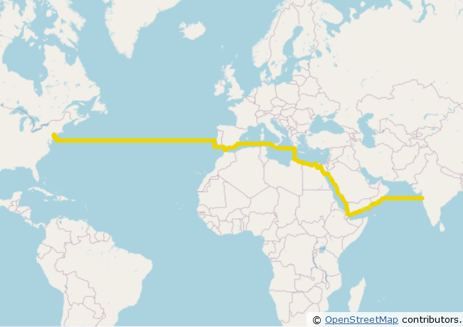
India to America road map via Spain (Europe route)
India New delhi to Usa Newyork by road and sea route distance is 17408 kilometer via Port of Algeciras,span.- Step 01.New delhi to wagah border. The route distance is 477km and it may take around 6:02 hours travel time.
- step 02.wagah border to Port of Algeciras Bay. The road distance is 10899km. The travel time is 117:44 hours.
- step 03. Port of Algeciras Bay, Spain to Port of New York, United States. The traveling distance is 3515 nm or 6509.78kilometer.
- Now you are at American land
India to America distance by sea route
India to America sea route distance is 9036 nautical miles. The routes goes as follows.- 1.Port of Mumbai
- 2. Arabian Sea
- 3. Gulf Of Aden
- 4. Red Sea
- 5. Gulf Of Suez
- 6. Suez Canal River
- 7. Suez Canal
- 8. Ismailiya Canal River
- 9. Nile River
- 10. Damietta Branch River
- 11. Mediterranean Sea
- 12. Alboran Sea
- 13. Strait Of Gibraltar
- 14. North Atlantic Ocean
Time Difference between India and America
India universal time is 5.1466666666667 Coordinated Universal Time(UTC) and America universal time is -5.136 UTC. The time difference between India and America is 10.282666666667 decimal hours. Note: India and America time calculation is based on UTC time of the particular city. It may vary from country standard time , local time etc.India To America travel time
India is located around 12053 KM away from America so if you travel at the consistent speed of 50 KM per hour you can reach America in 241.06 hours. Your America travel time may vary due to your bus speed, train speed or depending upon the vehicle you use.India To America road map
America is located nearly east side to India. The given east direction from India is only approximate. The given google map shows the direction in which the blue color line indicates road connectivity to America . In the travel map towards America you may find en route hotels, tourist spots, picnic spots, petrol pumps and various religious places. The given google map is not comfortable to view all the places as per your expectation then to view street maps, local places see our detailed map here.Travel information and User Writings about "Distance between India and America is 12053 KM / 7489.5 miles"
Delhi to America distance
The flight distance from India, New delhi to America Washington Dc distance is around 12,053 km. The flight will take around 16 hours journey. The cheapest and approximate flight fare is around 25,000 INR. The flight fare will vary due to various factors. Here we are taking New Delhi as India and Washington Dc as America.India to America distance by Road
There is no road between USA and India, because these two contries are seperted by ocean. So we have to go by flight or ship. If we go through Russia, you will be stranded on the East coast of Russia, Naukan Hykah with the Berring sea in the middle. If we go through Europe, we?ll reach Porspoder,France from where further journey will be impossible due to the presence of the North Atlantic Ocean.India to USA by Road
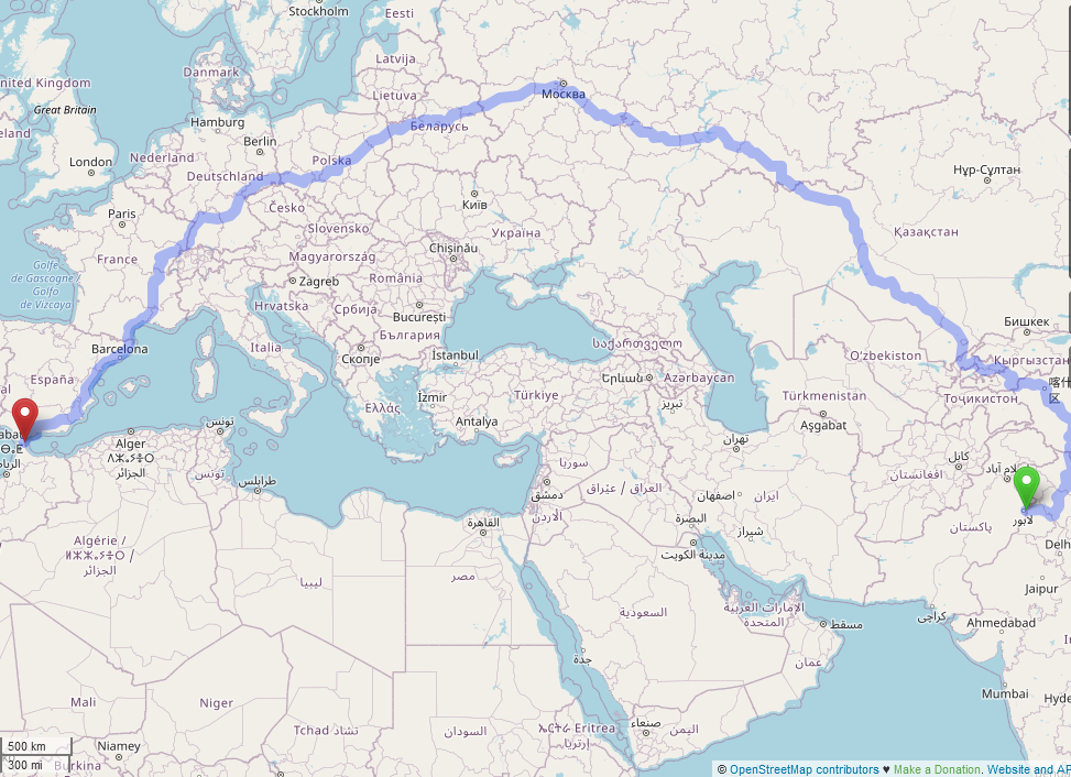
In future it may be possible. Russia plaing to construct long road. From India we can cross over to Nepal and then to Tibet(China). Any vehicles entering China will need new Chinese registration plates till the time they are in the country. Then from china to Kyrgystan and then to Kazakhstan. In Kyrgystan you?ll encounter tough road conditions with roads passing through some of the toughest terrain. Kazakhstan borders Russia and once there, you have to join the Trans Siberian Highway. Then drive across the breadth of the nation and cross the Bering Sea on a ship. From there you reach Alaska and drive via Canada to United States.India to America distance by flight
The flight distance from India, New delhi to America Washington Dc distance is around 12,053 km. The flight travel may take around 16 hours.Can I reach New York by Road from New Delhi ?
We can reach by road till the Europe . Then you have to cross the Atlantic Ocean, either via flight or via ship. Another way is we can reach the easternmost part of Russia, and take a flight to the Western coast of the U.S., and then travel by road to New York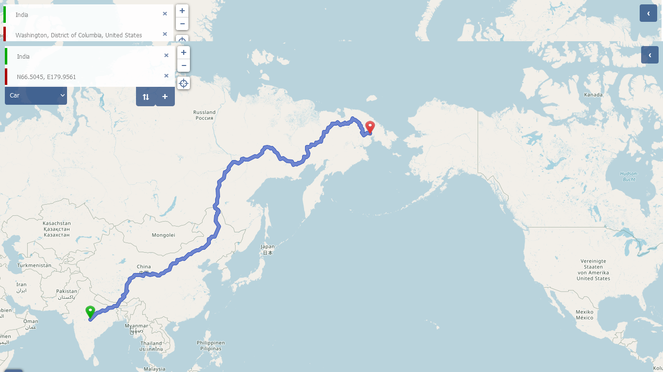
- distance between India and Portland
- distance between India and Portugal
- distance between India and Prague
- distance between India and Qatar
- distance between India and Quebec
- distance between India and Queensland
- distance between India and Quito
- distance between india and rangoon
- distance between India and Redmond
- distance between India and Rio
- distance between India and Riyadh
- distance between India and Romania
- distance between India and Rome
- distance between India and Rotterdam
- distance between India and Russia
- distance between India and Rwanda
Travelers and visitors are welcome to write more travel information about India and America.
- It can be your previous travel experience between India and America.
- Available transport routes to reach America like train routes, bus routes, air routes and cruise routes.
- Tourist places or any other important places on the routes between India and America.
- Hotels, restaurant information on the way to America.
- Photos related to India and America or en route.
- Travel queries and other relavent information related to this page.